


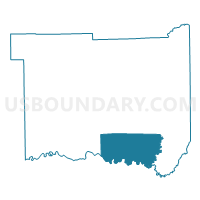
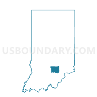
GRASSY FORK, Jackson County, Indiana
About
Outline

Summary
| Unique Area Identifier | 577940 |
| Name | GRASSY FORK |
| County | Jackson County |
| State | Indiana |
| Area (square miles) | 39.75 |
| Land Area (square miles) | 39.67 |
| Water Area (square miles) | 0.08 |
| % of Land Area | 99.80 |
| % of Water Area | 0.20 |
| Latitude of the Internal Point | 38.79116620 |
| Longtitude of the Internal Point | -85.98183110 |
Maps

Graphs
Select a template below for downloading or customizing gragh for GRASSY FORK, Jackson County, Indiana


Neighbors
Neighoring Voting District (by Name) Neighboring Voting District on the Map
- BROWNSTOWN TWP. EAST, Jackson County, IN
- DRIFTWOOD, Jackson County, IN
- GIBSON, Washington County, IN
- MONROE, Washington County, IN
- VERNON NORTH, Jackson County, IN
- VERNON SOUTH, Jackson County, IN
- WASHINGTON, Jackson County, IN
Top 10 Neighboring County Subdivision (by Population) Neighboring County Subdivision on the Map
- Brownstown township, Jackson County, IN (5,552)
- Vernon township, Jackson County, IN (3,419)
- Gibson township, Washington County, IN (1,176)
- Washington township, Jackson County, IN (1,122)
- Driftwood township, Jackson County, IN (860)
- Grassy Fork township, Jackson County, IN (668)
- Monroe township, Washington County, IN (558)
Top 10 Neighboring Unified School District (by Population) Neighboring Unified School District on the Map
- Seymour Community Schools, IN (27,072)
- Salem Community Schools, IN (12,830)
- Brownstown Central Community School Corporation, IN (10,375)
- Crothersville Community Schools, IN (3,419)
Top 10 Neighboring State Legislative District Lower Chamber (by Population) Neighboring State Legislative District Lower Chamber on the Map
Top 10 Neighboring State Legislative District Upper Chamber (by Population) Neighboring State Legislative District Upper Chamber on the Map
Top 10 Neighboring 111th Congressional District (by Population) Neighboring 111th Congressional District on the Map
Top 10 Neighboring Census Tract (by Population) Neighboring Census Tract on the Map
- Census Tract 9673, Washington County, IN (4,551)
- Census Tract 9672, Washington County, IN (4,529)
- Census Tract 9682, Jackson County, IN (4,205)
- Census Tract 9683, Jackson County, IN (3,419)